|
|
 |
 |
|
Citizens Concerned About the Future of the Etobicoke Waterfront
|
|
|
 |
|
Updated: January 30, 2026
|
|
|
|
|
|
|
|
|
|
 |
 |
|
November 10, 2016
Park Lawn / Lake Shore Area Transportation Master Plan
The City has embarked on a transportation study of the Lake Shore Blvd and Park Lawn area. This is a subject of great interest to everyone who lives near or travels through that area regularly. For CCFEW, or primary interest is ensuring that there is no further encroachment of transportation infrastructure into our parks. A few years ago, the plans for this area had the Mimico Loop relocating into Humber Bay Park East. The loop may be moved, but putting it in the park now appears much less likely.
Public meetings are scheduled for November 24th and December 3rd. Note that the December 3rd session has been moved to the afternoon. Click on he images below for links to their newsletter and minutes of last month’s Stakeholder Meeting.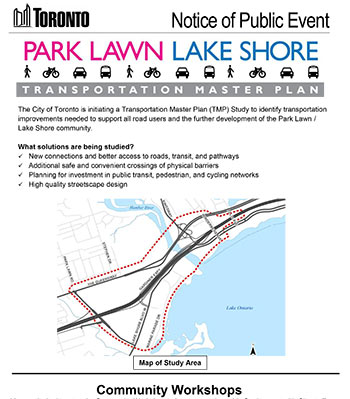
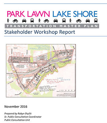
For more information, visit the project website, toronto.ca/parklawnlakeshore.
|
|
 |
 |
 |
 |
 |
 |
 |
 |
 |
 |
 |
|
November 9, 2016
Trail Projects Approved by City Council
City Council approved the commencement / continuation of work on the South Mimico Trail, Sherway Trail Extension, and the North Etobicoke Trail. The motion stated in part:
“...move forward with completing the portion of the South Mimico Creek Trail Link on the east side of Mimico Creek in 2017...”
“In the event the Queen Elizabeth Way bridge replacement work by the Ministry of Transportation is delayed and is not scheduled to begin by the end of 2018, City Council request the General Manager, Parks, Forestry and Recreation to work with Toronto and Region Conservation Authority to proceed with the construction of the Sherway Trail Link of the Etobicoke Creek Trail in 2017.”
You can read the full decision here.
|
|
|
|
October 22, 2016
Etobicoke Trail Projects Moving Forward
Following a confusing Community Council resolution in June, Councillor Grimes moved a motion at the October meeting to proceed with construction of three new trail projects in Etobicoke:
- The Sherway Trail, connecting the South Etobicoke Creek Trail north under the QEW to Sherway Drive
- The South Mimico Trail Link, running north along Mimico Creek from Lake Shore Blvd. W., connecting to the existing trail north of teh CN railway.
- The North Etobicoke Trail, along the east side of Etobicoke Creek at Centennial Park.
You can read the Staff Report here, and coverage from the Etobicoke Guardian here.
The motion received unanimous approval from Community Council. We just need City Council approval next month, and these projects will finally be moving forward!
|
|
|
|
October 11, 2016
Humber Bay Parks Masterplan Update
The third public meeting for the Humber Bay Parks Masterplan was held on September 29th. Information panels and the Discussion guide/Workbook are available at www.toronto.ca/humberbayparks. You have until October 19th to submit comments on the material and ideas presented at the September 29th meeting.
|
|
|
|
 |
|
|
|
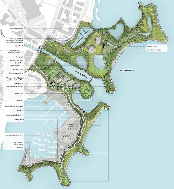
Humber Bay Parks Master Plan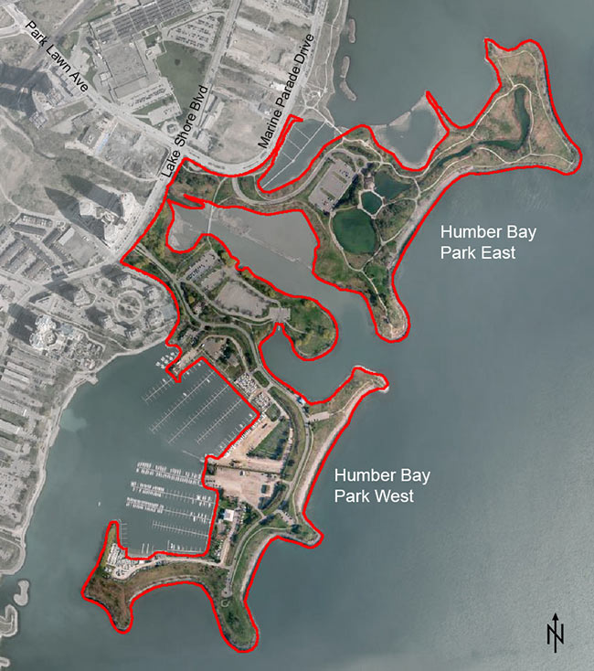
The purpose of the Park Master Plan is to:
- establish a vision and design to protect and enhance the highly valued naturalized landscape, habitat and recreational uses in the park
- improve safety and access to the park
- ensure that proposed improvements respond to existing and future needs of the community and city residents
May 27, 2016
CCFEW is a member of the Community Resource Group (CRG) which has now had two meetings. The very controversial pavilion project is currently on hold, but not officially canceled. Funds earmarked for the pavilion may be redirected to any structures identified as desirable in the Park Master Plan process as long as the contract isn’t canceled.
Many exciting ideas have been put forward to reduce paved surfaces and improve circulation, and encourage users to make use of both sides of the park.
The project website is being updated regularly.
The second public meeting is scheduled for June 15, and the online survey is open until June 10th.
You can scroll down this page to see earlier comments and concerns about the project.
|
|
|
|
Waterfront Transit Reset
The City, Waterfront Toronto, and the TTC are looking at a a variety of new and old ideas for transit along the waterfront from the Long Branch GO Station to Woodbine Avenue with the goal of creating a comprehensive transit network from west to east. The first two public meetings were held on May 25 & 26th.
You can visit the project website here and, until June 3rd, take the online survey here.
|
|
|
|
April 8, 2016
Lake Shore Blvd West Cycle Track Approved
Last week City Council unanimously approved the Lake Shore Blvd W cycle track. This separated, bi-directional cycle lane will run between Norris Crescent and First Street.
The same council motion also approved the contra-flow bicycle lane on Waterfront Drive, from Marine Parade Drive to Palace Pier Court. This will make it easier for cyclists to legally bypass an often congested section of the Waterfront Trail at Humber Bay Shores.
Here’s the text of the motion passed by City Council:
1. City Council approve the installation of an eastbound contra-flow bicycle lane on Waterfront Drive, from Marine Parade Drive to Palace Pier Court, as described in Appendix 1 – Amendments to Bicycle Lane and Cycle Track Designations, attached to the report (January 25, 2016) from the General Manager, Transportation Services.
2. City Council approve the installation of a bi-directional cycle track on the south side of Lake Shore Boulevard West, from Norris Crescent to First Street, as described in Appendix 1 – Amendments to Bicycle Lane and Cycle Track Designations, attached to the report (January 25, 2016) from the General Manager, Transportation Services.
3. City Council enact the traffic and parking regulation amendments associated with the above Parts 1 and 2 as described in Appendices 2 and 3 attached to the report (January 25, 2016) from the General Manager, Transportation Services.
4. City Council direct the General Manager, Transportation Services to report to the June 14, 2016 meeting of Etobicoke York Community Council on plans to re-introduce and encourage cycling on Lake Shore Boulevard West, between the Humber River and Norris Crescent.
5. City Council request the General Manager, Transportation Services to consider closing the gap on winter maintenance performed by Transportation Services staff along the Waterfront Trail by extending the maintenance area further west to the border of Mississauga, including 4.5 km of additional trail from Park Lawn Road to Norris Crescent through Mimico Linear Park, through Colonel Samuel Smith Park and through Marie Curtis Park at a cost of approximately $35,000 annually, and City Council request the General Manager, Transportation Services to bring it forward as part of the 2017 budget deliberations.
6. City Council authorize and direct the appropriate City officials to take the necessary action to give effect to Council's decision, including the introduction of all necessary bills.
You can find out more on the Project Page of the City’s website.
|
|
|
|
March 8, 2016
Humber Bay Park Master Plan Comments
The comment period following the initial public meeting for the Humber Bay Master Plan closes today. We submitted the following comments following our meeting yesterday. The comments follow the question format laid out in the City’s comment form:
Vision & Outdoor Activities
1. What is your vision for Humber Bay Park East and West?
CCFEW’s vision of the Humber Bay Parks is a place for passive recreation in a primarily naturalized environment. As noted in the TRCA’s Terrestrial Biological Inventory and Assessment, Humber Bay East has the greatest amount of, and potential for, high quality naturalized spaces. These areas should be protected and enhanced as much as possible. Humber Bay Park West is never likely to have the same quantity and quality of naturalized spaces due to the large portion of the park occupied by boating clubs.
2. What activities would you like to be included as part of the Master Plan?
The Master Plan should focus on passive recreational activities. These would include walking, cycling, nature viewing, fishing, and picnicking.
Pavilion & Related Activities
1. What is your vision for a Pavilion at Humber Bay East?
The pavilion is an ill-conceived notion with no clear use or purpose. It is very reminiscent of the Power House at Colonel Samuel Smith Park. That facility sat largely unused for years despite having a fully staffed community centre (Ken Cox) just 200 metres away. To date, the only long term, ongoing use it has found is as a skate changing facility for the skating trail.
The pavilion has been described both as a community centre, and as not a community centre. We should not be putting a community centre in these parks. Humber Bay Parks may have been large and underused when they were first built, but they are now heavily used, and highly valued, as the surrounding area continues to be transformed into a dense urban residential area. The site identified for the pavilion is in, or adjacent to, the areas identified as having the best quality natural habitat and the areas most sensitive to disturbance from development. Many of us have been pointing out for years that there are no community centres, libraries, or schools being built for all these new residents. That is no justification for now carving a piece out of a waterfront park to address that deficiency.
The community deserves a true community centre, not a pseudo community centre occupying precious waterfront park space. It should be a priority in the development plan for the Mondelēz (former Christie) site.
2. What are the activities that should be accommodated in the Pavilion design?
As stated above, we see no clear use for the pavilion. If it is going to be open, it must be staffed. If it is staffed it must be programmed. If it is programmed, it must be a community centre. A community centre doesn’t belong in a waterfront park.
Natural Environment & Ponds
1. With respect to the natural environment and ponds, what issues should be considered in the Master Plan?
The plan should consider a strategy of replacing exotic species with native ones, where practical, and controlling invasives. Upgrades to the existing trail network should be considered, both to prevent erosion and trampling, and to maximize the size of contiguous habitat blocks providing shelter for a variety of wildlife.
2. With respect to the natural environment and ponds, what opportunities should be considered in the Master Plan?
- Designated viewing locations, possibly elevated, should be considered at the eastern pond and wetland regeneration embayments to reduce damage from informal access routes.
- Areas of high quality habitat, particularly in Humber Bay East, should be protected and enhanced.
- A wind-powered pumping system should be considered for the ponds. This could provide an opportunity to learn about old technology and sustainable solutions while providing a low cost pumping solution.
- The stormwater management ponds create important wildlife habitat, particularly in the final stage pond. The floating walkway provides excellent viewing opportunities. Further habitat enhancement and protection of the south-east shoreline should be considered.
Circulation, Parking & Accessibility
1. With respect to circulation, parking and accessibility, what issues should be considered in the Master Plan?
There is a very large portion of Humber West dedicated to parking. A study should be undertaken to determine if there is an oversupply. Humber Bay Park West is under-used. A combination of trail realignment and signage should be used to encourage more people to explore there. The remaining boat launch at Humber Bay West is an important facility that should be maintained. There are very few other public boat launches on the western waterfront. There are extensive informal trails in Humber Bay East. Most of these should be upgraded to formal trails in order to reduce damage to surrounding vegetation.
2. With respect to circulation, parking and accessibility, what opportunities should be considered in the Master Plan?
- Many informal trails should be upgraded so they don’t become muddy quagmires in winter and spring.
- Signage and trail connections should be improved in Humber Bay West to encourage more users to explore the outer portion of the park. Cyclists should be encouraged to use the roadway in Humber Bay West in order to reduce the need to widen the existing paved trail.
- The Air India Memorial should be modified so that it is possible to pass without using stairs. There is a muddy path around it created by people with bicycles, strollers, wheelchairs, etc.
- The Mimico Creek bridge is a pinch point. Creating a lookout platform at one end would help by creating a place other than the bridge for people to stop and look at the creek and lake.
These comments are submitted by consensus on behalf of Citizens Concerned About the Future of the Etobicoke Waterfront (CCFEW)
Click here for a pdf version of the comments.
|
|
|
|
March 7, 2016
Lake Shore West Cycle Track - One Step Closer
The Lake Shore West Cycle Track is one step closer to reality after receiving unanimous approval at last week’s meeting of the Public Works and Infrastructure Committee.
Next stop is City Council on March 30th.
|
|
|
|
February 29, 2016
“Stop the Pavilion” Petition
There was so much concern and outcry at and following the February 16th public meeting about the Humber Bay parks master Plan, that the Friends of Humber Bay Park started a petition to stop the construction of a pavilion in Humber Bay Park East.
As of today, it has over 700 signatures.
|
|
|
February 24, 2016
Humber Bay Parks Project – Master Plan and Pavilion
We knew the Humber Bay Parks Master Plan was due for review this year. What we didn’t know until last week was the centerpiece of the plan was a new 12,000 square foot, $7,000,000 pavilion in Humber Bay Park East.
You can find out more on the City’s Humber Bay Parks Project Page. Public comments are being accepted until March 8th.
Here is the project timeline: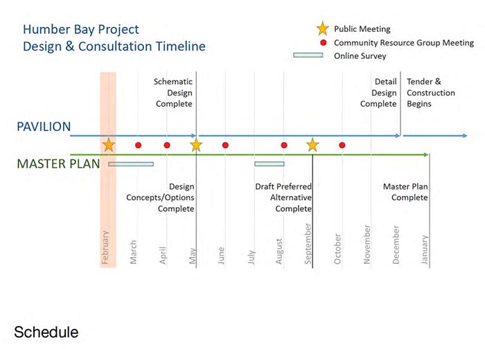
There is a lot of information on the project page, but one document that’s not there, and should inform the whole process, is this Terrestrial Biological Inventory and Assessment prepared by the TRCA in 2014. If you want to skip all the methodology, the Recommendations Section starts on page 22.
|
 |
The Ontario Municipal Board (OMB) hearing considering appeals of the Mimico by the Lake (Mimico 2020) secondary plan resumes on:
Tuesday, February 2nd, at 10:00 am
Location: 655 Bay Street, 16th Floor (MAP)
“We cannot let one landowner undo the work of many”.
Mimico Lakeshore Community Network
Final rounds in the tale of tall condo towers on the Shoreline Towers lot!!
The owners of Shoreline Towers have appealed the Mimico-by-the-Lake Secondary Plan to the Ontario Municipal Board (OMB) to allow for more big buildings on their property.
Last November, as part of their presentation before the OMB, the Shoreline Tower planner proposed a new potential redevelopment scenario, which would open the door for Shoreline to construct a tower of up to 15 storeys between the existing buildings and the lake, and later replace the existing buildings with two 25-storey towers. That would undo the great work of city planning staff and throw away the fruit of seven years of public consultations, wasting over half a million dollars of taxpayers’ money and setting the precedent for a free-for-all for builders of skyscrapers on the Mimico waterfront.
The hearing on the appeal resumes on Tuesday, February 2. Having a crowd of concerned residents at the first day of the resumed hearing will send a message to the Board that people care about the future of their neighbourhood.
Join us on February 2, 2016, 10:00 a.m., at 655 Bay Street, 16th Floor as we, the community, show strong support for the implementation of the Mimico-by-the-Lake Secondary Plan as approved by City Council.
We know the time is inconvenient for residents; it’s what suits the professionals! Please try to be there!
Mimico Lakeshore Community Network Inc.
lakeshorenetwork@gmail.com
|
|